Scrap Book - Doco - Documentation - Media Snippets
"The fact that an opinion has been widely held is no evidence whatever that it is not utterly absurd; indeed, in view of the silliness of the majority of mankind, a widespread belief is more likely to be foolish than sensible."
Bertrand Russell, Marriage and Morals, p. 58
Tuesday, September 30, 2008
Private Spies - Corporations rogue SUBVERSIVES
When Corporations Spy
by Tom Burghardt September 30, 2008
As if illegal spying and dirty tricks by state agencies weren't threat enough to democratic institutions and grassroots activist organizations, hundreds of corporate spy outfits are doing their part--to defend the "homeland" and the bottom line--for the multinational grifters who plunder the world's wealth.
SourceWatch revealed that Hakluyt & Company, Ltd., a "British private intelligence agency ... staffed almost entirely by ex-intelligence services staff," was outed by a freelance journalist after the company sought to recruit her "services." The group reported in August:
Melissa Sweet, a freelance Australian health journalist, reports that she recently received an email from a staffer with Hakluyt. In it she was asked if she would like to become part of a "network of well-placed individuals around the world who are able to provide us, very discreetly, with intelligence on specific commercial or political issues that may arise." In particular, they were seeking her assistance for an anonymous "financial institution" client on "a new project on the new Australian government's healthcare policy--how realistic their reform ambitions really are", "the role of the private sector" and other matters. Sweet responded by pointing out that she was a journalist not a consultant. Undeterred, the Hakluyt staffer wrote back explaining that as a journalist she was likely to have "dozens of well-placed sources in the field" and that the company already has "a number of quality, usually specialist journalists that we deal with". In 2001 Hakluyt was outed for infiltrating Greenpeace in Europe. ("Hakluyt & Company Limited," SourceWatch, August 1, 2008)
The Sunday Timesreported in 2001 that Hakluyt hired Manfred Schlickenrieder, a German foreign intelligence operative tasked by the firm to spy on Greenpeace at the behest of oil giants BP and Shell. According to The Sunday Times:
His political credentials seemed impeccable: he had once been chairman of the Munich branch of the German Communist party and the bookshelves of his office held the works of Bertolt Brecht, the Marxist playwright and poet.
Behind the facade, however, Schlickenrieder was a spy working for both the German secret service and for Hakluyt, a private intelligence agency based in London's West End and set up by former officers of MI6, the secret intelligence service. His codename was Camus after Albert Camus, the existentialist author of L'Etranger.
Hakluyt paid him thousands of pounds to inform on the activities of Greenpeace, Anita Roddick's Body Shop and other environmental campaigners. The BND, the German equivalent of MI6, allegedly paid him £3,125 a month living expenses. (Maurice Chittenden and Nicholas Rufford, "MI6 'Firm' Spied on Green Groups," The Sunday Times, June 17, 2008)
Also in 2001, after the Greenpeace scandal exploded, Christopher James, Hakluyt's Managing Director, wrote to the disgraced CEO of Enron, the convicted felon Jeffrey Skilling, bragging of Hakluyt's unique "services":
The range of deployments we have completed for core clients is wide. In all cases we guarantee complete confidentiality. And, although we work for divisional directors on tactical issues, we have found our most rewarding work in personal dealings with CEOs who wish--for whatever reason--to have a confidential agency at their own disposal. It was this, which prompted Phil Carroll to write to you about us in April as he has found our work of considerable value to him personally. We look at people and the issues, which often drive them to make the decisions or act as they do. All our work is unattributable.
To sweeten the pot, James told Skilling,
We also have an association with Kissinger/McLarty Associates for although our work is very different the services we both provide can be complementary. Our US client base is increasing well but at the same time we wish to remain small and discreet. (Confidential email from Christopher James to Jeffrey Skilling, posted by Enron Explorer, July 8, 2001)
Talk about a small (and very greedy) world!
But Hakluyt wasn't the only firm engaged in corporate espionage targeting green groups. As investigative journalist James Ridgeway reported last April,
A private security company organized and managed by former Secret Service officers spied on Greenpeace and other environmental organizations from the late 1990s through at least 2000, pilfering documents from trash bins, attempting to plant undercover operatives within groups, casing offices, collecting phone records of activists, and penetrating confidential meetings. According to company documents provided to Mother Jones by a former investor in the firm, this security outfit collected confidential internal records--donor lists, detailed financial statements, the Social Security numbers of staff members, strategy memos—from these organizations and produced intelligence reports for public relations firms and major corporations involved in environmental controversies. ("Cops and Former Secret Service Agents Ran Black Ops on Green Groups," Mother Jones, April 11, 2008)
The firm, the now-defunct Beckett Brown International, provided a "range of services" for heavy-hitting corporate clients including Allied Waste, the Carlyle Group, Halliburton and Monsanto. Headquartered in Easton, Maryland, BBI "worked extensively" for public-relations firms Ketchum, Nichols-Dezenhall Communications, and Mongoven, Biscoe & Duchin. According to Ridgeway,
At the time, these PR outfits were servicing corporate clients fighting environmental organizations opposed to their products or actions. Ketchum, for example, was working for Dow Chemical and Kraft Foods; Nichols-Dezenhall, according to BBI records, was working with Condea Vista, a chemical manufacturing firm that in 1994 leaked up to 47 million pounds of ethylene dichloride, a suspected carcinogen, into the Calcasieu River in Louisiana.
BBI was apparently good at what they did until the firm ran to ground in 2001, provoked by "infighting between the principals." But don't despair, Ridgeway tells us that "the firm's officials went on to work in other security firms that remain active today." Call it another prime example of keeping the "homeland safe"--and profitable--for the corporate grifters who ceaselessly labor to destroy "our way of life." Their dream, our nightmare.
Big Budgets, Global Reach
With global reach, seemingly limitless budgets and often staffed by ex-military and security operatives, the world of private spying is a big business with a huge growth potential, particularly when citizens revolt against the sordid schemes of corporate polluters, defense contractors and resource grabbers.
Indeed, as legendary researcher Frank J. Donner documented in his landmark books, The Age of Surveillance and Protectors of Privilege, "a more functional public-private linkage is often found on the urban and state levels" where connections amongst right-wing groups, corporations and the government abound.
Historically, this nexus included organizations such as the semi-official Law Enforcement Intelligence Unit (LEIU), ultrarightist outfits such as the John Birch Society, Church League of America, the Minutemen, Legion of Justice, the American Security Council, and "legitimate" private detective agencies such Pinkerton, Kroll, Burns and Wackenhut.
But as the corporatist state totters on the brink of economic collapse, in no small part the result of greed and gross criminality by top-flight financial institutions, banks, investment firms and other corporate grifters linked to the Bush administration and the Republican and Democratic parties, the capitalist state will require a vast legion of private spooks to "keep the rabble in line."
There certainly are plenty of them.
In 2006, the World Socialist Web Sitereported that high-tech powerhouse Hewlett-Packard was caught red-handed in a corporate spies-for-hire scheme to stanch leaks.
The spying campaign, launched by H-P board Chairwoman Patricia Dunn in response to leaks to the press of internal corporate discussions, included surreptitiously obtaining the phone records of H-P board members and employees, surveillance of board members and journalists, and the emailing of spyware to journalists in an effort to learn the identity of their sources within the company.
Private telephone records on hundreds of cell and home telephones were obtained by a method called "pretexting," in which investigators made repeated calls to telephone companies, pretending to be the individuals targeted, until they were able to convince a phone company employee to release the information. (Patrick Martin, "Hewlett-Packard spying scandal sheds new light on U.S. corporate 'ethics'," World Socialist Web Site, 2 October 2006)
The corporate spooks, their tradecraft acquired through years of practice as dodgy state operatives, were hired through a series of "cutouts" designed to provide top company officials with "plausible deniability" should their cover be blown.
Among the firms employed by H-P were the Boston-based Security Outsourcing Solutions (SOS). According to Martin, the "dirty work" was outsourced to Action Research Group (ARG) of Melbourne, Florida. A blurb on SOS's website claims that the company will "work with internal security departments that do not have the expertise and or resources to address all of their organization's security concerns."
That's rich, considering that H-P clocks in at No. 14 on the 2008 Fortune 500 list and recently agreed to pay $12.6 billion to buy out Electronic Data Systems! An additional subcontractor, Eye in the Sky Investigations, described itself as providing (as of 2004) "skip tracing services" for "the licensed private investigator, finance company, collection agency, recovery agency, bail bondsman, info brokers." A handy list of charges for company "services" was even listed on Webspawner.
While ARG's website is blocked, a simple Google search uncovered a "Complaint for Injunctive and Other Equitable Relief" filed February 14, 2007 by the Federal Trade Commission (FTC) in United States Federal District Court, Orlando Division, against ARG and Eye in the Sky Investigations.
The complaint against corporate officers of the firms charged the companies with gross violations of the Telecommunications Act of 1996 for illegally obtaining "customer proprietary network information."
Indeed the FTC accused ARG and other defendants in the suit with engaging in an egregious "invasion of privacy" of confidential customer phone records "likely to cause substantial harm to consumers." According to court documents:
The account holders have not authorized Defendants to access or sell their confidential customer phone records. Instead, to obtain such information, Defendants have used or have caused others to use, false pretenses, fraudulent statements, fraudulent or stolen documents or other misrepresentations, including posing as an account holder or as an employee of the telecommunications carer [sic], to induce officers, employees, or agents of telecommunications carers [sic] to disclose confidential customer phone records. Defendants have sold the confidential customer phone records that they have obtained to their clients or others.
Sounds like business as usual to me!
The San Francisco Business Timesreported in May that the named defendants agreed to pay some $600,000 to settle the case with the FTC for their role in the illegal H-P spying operation. Keep in mind, this is but one case in what must be a tsunami of illegal covert operations by American corporate behemoths!
Wal-Mart and Raytheon: Best Friends Forever!
While the hunt for "subversives," often under the direction of corporate associations such as the National Association of Manufacturers, the American Chamber of Commerce and related "defense" industry trade and lobby shops, occupied corporate spooks during the McCarthy period, by the late 1970s and down to the present moment, environmental, labor, antiwar, antinuclear, antiglobalization and increasingly, civil liberties and privacy advocates have entered the frame, often with a vengeance.
Indeed, according to Wal-Mart Watch, the retail giant's Threat Research and Analysis Group conducted extensive spying operations against critics and employees until it was revealed by a whistleblower. Bruce Gabbard told The Wall Street Journal,
Wal-Mart began beefing up its electronic call surveillance after the Sept. 11, 2001, terrorist attacks in response to government requests to employers in general to help find terrorist cells. Mr. Gabbard says he was directed by two former FBI agents working for Wal-Mart to set up a system that could track any calls to and from Syria, Yemen and Iran, among other countries. The search was unsuccessful, only flagging an apparent call from Iran that turned out instead to be from an Indian jeweler, according to Mr. Gabbard.
Later, he says, he used the same equipment to intercept and record calls from the New York Times. (Ann Zimmerman and Gary McWilliams, "Inside Wal-Mart's 'Threat Research' Operation," The Wall Street Journal, April 4, 2007, Page B1)
Wal-Mart whistleblower Gabbard said the electronic surveillance "accelerated" in 2005 when leaked documents began appearing on the website of the pro-union group Wal-Mart Watch. One memo "suggested" that because of rising healthcare costs and criticism of the corporate giant's policies "the retailer should revise its policies by hiring healthier workers and requiring all jobs to perform physical activity, such as retrieving shopping carts."
According to the Journal, Wal-Mart began working with Oakley Networks Inc., a developer of "insider threat management" gear to surveil employee computer usage over the retail giant's network. Indeed, the Journal reports that one Oakley system is capable of recording an employee's keystrokes "and deliver a TiVo-like replay of his or her computing activities."
While confirming the "advanced capabilities" of its system, Oakley Networks refused to identify its customers "apart from the U.S. Defense Department." Zimmerman and McWilliams reported that "the system goes beyond keystroke capture products and email filtering packages" providing "a view of content" moving across a targeted network.
Oakley Networks Inc., now a wholly owned subsidiary of Raytheon (Raytheon Oakley), was founded in 2001 and "acquired" in 2007 by the defense giant. It is now a major component of Raytheon's "Intelligence and information Systems (IIS) business." According to a blurb on their website, "Raytheon Oakley protects 10 of the Fortune 100 banking, technology, manufacturing and other critical commercial infrastructure companies." Washington Technologyreported "terms [of the deal] were not disclosed."
And with "security" in the heimat the latest frontier to be conquered by "war on terror" corporate profiteers, is it any wonder that private surveillance has become a lucrative growth industry. Indeed, there's even a trade association, the Homeland Security Industries Association (HSIA)! A Washington, D.C.-based lobby group, HSIA describes its mission as providing "a mechanism for government and the private sector to coordinate on a wide range of homeland security issues."
And do they ever coordinate!
Members include corporate heavy-hitters such as Bechtel, Fluor Corp., Lockheed Martin, Raytheon, Textron and Washington Group International. Mid-sized firms such as E.J. Krause & Associates, Intelsat Government Solutions, Galileo International, Shaw Group, and Worldwide Security Associates. Additionally, smaller firms and universities include AR Challenges, Georgetown University, Intelliorg, the John Hopkins Applied Physics Lab, and QED are saddled-up in HSIA's stable.
Without another major terrorist attack like those of 9/11, Homeland Security Research, the industry tracker, expects the market for security goods and services to increase to $178 billion in 2015, or triple its current value.
But a major attack in the United States, Europe or Japan could increase the global market in 2015 to $730 billion, more than a twelvefold increase, the company says.
Most of the growth this decade will come from building what Homeland Security Research calls "a homeland defense infrastructure." Growth areas are likely to include technology for surveillance and for detection of nuclear and other weapons of mass destruction. (Gary Stoller, "Homeland security generates multibillion business," USA Today, September 10, 2006)
As can be seen from this overview, corporate spying like "outsourcing" state security and intelligence functions to corporatist "partners" are another means of providing "plausible deniability," global reach and maximum capabilities in the subversion of democratic institutions in the service of imperialist Empire.
We can be certain of this: as the American economic house of cards continues its epochal collapse, a viper's nest of state and private intelligence operatives will be unleashed upon the American people.
Tom Burghardt is a researcher and activist based in the San Francisco Bay Area. In addition to publishing in Covert Action Quarterly, Love & Rage and Antifa Forum, he is the editor of Police State America: U.S. Military "Civil Disturbance" Planning
http://members.shaw.ca/mclachla/page3.htm Get the Truth -by Lesley Hughes
Last week Canada revealed itself once again as a truly unique nation. In a world where dead warriors are commonplace and taken for granted, this country stopped, paid attention, lowered the flags and gave full military honours to four soldiers, who died inexplicably and tragically at the hands of our allies.
We all felt the shock and the sorrow. The corporate media, privately owned newspapers, television and radio chains lingered especially on the pain and dignity of their survivors.
This was hard to swallow, coming from the same media that, in a fit of Me-Too-ism, couldn't wait to send young Canadians into a war on terrorism, which they hardly bothered to investigate; the same media that show every willingness to sacrifice more lives and families without pausing to confront the most basic question Canadians want answered about Afghanistan. What, exactly, are we doing there?
Truth may have been the casualty of war in former ages, but this war is different. While major media busy themselves waving flags, a global network of independent journalists, who have no interests to protect, no secrets to hide, are tracking and documenting its development on a daily basis.
Among the best: the Web site The Emperor's New Clothes (www.tenc.net) and Mike Ruppert, editor and publisher of From the Wilderness newsletter out of California (www.copvcia.com) .
Using and sharing only published and sourced news stories from world media, and official documents of various governments either leaked or available under freedom of information acts, these journalists have assembled a disturbing picture, which suggests CIA foreknowledge and complicity of highly placed officials in the U.S. government around the attacks on the World Trade Center Sept. 11.
Many official sources are claiming to have warned the American intelligence community, which spends $30 billion a year gathering information, about the attacks on the twin towers on that heartbreaking day.
German Intelligence (BND) claims to have warned the U.S. last June, the Israeli Mossad and Russian Intelligence in August. Israeli businesses, which had offices in the Towers, vacated the premises a week before the attacks, breaking their lease to do it. About 3000 Americans working there were not so lucky.
Ironically, the stock market was also warning anyone who cared to notice that something peculiar was afoot: in the week prior to Sept. 11, unknown speculator(s) were suddenly betting that the stocks of United Airlines and American Airlines were going to fall in value; the trades were placed through Deutschebank/AB Brown, a firm formerly managed by Buzzy-Krongard, now executive director of the CIA.
So far, no one has been bold enough to claim $2.5 million in profits. No serious search for the speculator is under way.
More important to Canadians, the facts uncovered by Internet journalism suggest that the war in Afghanistan has little to do with the attacks of Sept.11; that it's the result of lengthy failed negotiations between American businessmen and the Taliban over access to drugs and oil.
Mike Ruppert, a former LAPD narcotics officer turned journalist, maintains that Wall Street, (from whom the CIA gets its strategists and directions) is heavily dependent on laundered drug money, which helps keep the Fortune 500 and the stock market afloat. The IMF recently estimated that about $1.5 trillion goes through the world's banks every year, at least $500 billion of it from drugs.
His documents show that in January, 2001, the Taliban destroyed their opium crops, which normally supply 70 per cent of the world's heroin. In May, the U.S. gave the Taliban $43 Million in mysterious aid. Sept. 11 was a turning point.
The U.S. bombed, invaded, captured the Taliban, and opium farms are now back in business. The Financial Times has reported that the next harvest will be a record breaking 4,500 tonnes, much of it headed to the U.S.A.
Ruppert and others have tracked the progress of an urgent pipeline, which American oilmen have been trying to build through Afghanistan since 1991. They stated publicly that they could not do it without a sympathetic Afghan government in place. Newly installed prime minister Hamid Karzai is a former employee of Unocal Oil.
Negotiations on the Central Asian pipeline resumed in October and an agreement to proceed with it was announced in February.
Ruppert also notes that Osama Bin Laden was treated for his chronic kidney disease at the American Hospital in Dubai last summer. Although wanted for the bombing of two U.S. embassies and eligible for execution by American agents, he flew away undisturbed. The sole coverage of these events in Canada has come from Barrie Zwicker, media critic at Vision TV.
If the work of Internet journalists is correct, then the war is neither a holy war, not a grand clash of civilizations between East and West, and our soldiers were lost to us and to their families to keep drugs and oil profits flowing in the U.S.
Until we know the truth, we should refuse to add one more Canadian body to the pile of dead in Afghanistan. Not one. Canada should get the truth or get out.
Lesley Hughes is a freelance writer and broadcaster in Winnipeg. Reprinted with permission. Since Lesley’s column on May 1, the mainstream media have at last also "discovered" elements of this deeper, more sinister, story.
Winnipeg broadcaster Lesley Hughes welcomes everyone to the event.
Lesley Hughes, MC for the event
Hughes faced intense criticism for a column she wrote in 2002 as a freelance journalist, in which she suggests that Israeli intelligence warned the U.S. in advance of the Sept. 11 attacks and that Israeli businesses vacated the World Trade Center before two passenger planes struck the buildings.
Hughes, a former CBC journalist, also referred readers to websites that assert "CIA foreknowledge and complicity of highly placed officials in the U.S. administration around the attacks on the twin towers."
Liberal Leader Stéphane Dion has asked Winnipeg-area candidate Lesley Hughes to step down over an old column in which she suggested Israeli companies were given a heads-up about the Sept. 11, 2001, attacks on the U.S.
"It's the theatre of the absurd," said Hughes.
"I have no time for conspiracy theories about the Jewish population whatever," she said. "The article that I wrote — for anyone who reads it carefully — is very clearly innocent of any kind of anti-Semitic feeling. I am just absolutely stunned by this.
"I guess that's how soldiers die in the trenches. This is how it must feel."
Since the Sept. 22 nomination deadline has passed, Hughes name will still appear on the ballot and she could technically win, though not under the Liberal banner. Hughes said she hasn't decided yet whether she will continue campaigning.
If former Liberal candidate Lesley Hughes is an antisemite, then George Bush is Mahatma Ghandi, Stephen Harper is Mother Theresa and Stephane Dion is capable of leading Canada.
Of course, none of the above is true. In dumping Hughes, a well respected Winnipeg journalist and social activist, Dion has buckled under the pressure of the pro-Israel lobby and proven himself incapable of developing independent foreign policy for Canada. How else are we to judge a man who accepts the nonsense that any criticism of Israel, no matter how minor, is antisemitic?
The article that cut short Hughes brief career as a Liberal candidate, Get the Truth, raises a series of questions about the events leading up to the September 11, 2001 attacks on the World Trade Center and the Pentagon. The sad irony is that the article did not even criticize Israel.
In an online readers poll today, the Winnipeg Free Press asked: “Do you think Liberal leader Stephane Dion was right to turf Lesley Hughes over 9/11 conspiracy writings?” Of the 2,469 readers who have responded to date, 73 percent have said “No.”
Stephane Dione has not done his party any favours in Winnipeg.
======== USA MILITARY AIRBASES ==============
This is the html version of the file http://www.f-16.net/modules.php?op=modload&name=Downloads&file=index&req=getit&lid=40. G o o g l e automatically generates html versions of documents as we crawl the web. To link to or bookmark this page, use the following url: http://www.google.com/search?q=cache:6WqZKifHuRMJ:www.f-16.net/modules.php%3Fop%3Dmodload%26name%3DDownloads%26file%3Dindex%26req%3Dgetit%26lid%3D40+h1+h2+h3+h4+balad++sahra&hl=en&ct=clnk&cd=6&client=firefox-a Google is neither affiliated with the authors of this page nor responsible for its content. These search terms have been highlighted: h1 h2 h3 h4 balad sahra Page 1 USAF /DoD 111.2403.72 Rev SP3a F-16 C/D BL52 ODS 1/15 CONTENTS USAF /DoD 111.2403.72 Rev SP3a F-16 C/D Block 52 Navigation : ODS Volume F-16 C/D BL52 ODS 0/15 Not suited for Real Operations For FALCON 4.0 SuperPAK Use Only 1. Contents. 2. TACAN Selection Normal and backup mode. 3. Blank for Notes. 4. Kuwait and Saudi Arabia airbases. 5. Saudi Arabia airstrips, UAE, Qatar and Bahrain airbases. 6. Israel airbases & airstrips. Lebanon. 7. Iraq airbases. 8. Iraq airbases (continued) and airstrips. 9. Iran airbases. 10. Iran airstrips, Egypt airbases. 11. Egypt airstrips and Syria airbases. 12. Jordan airbases & airstrips, Azerbaijan, Turkmenistan and Armenia airbases. 13. Turkey & Cyprus airbases. 14. Kill boxes. 15. ODS Map. Page 2 USAF /DoD 111.2403.72 Rev SP3a F-16 C/D BL52 ODS 2/15 TACAN LIST FOR ODS THEATRE USAF /DoD 111.2403.72 Rev SP3a F-16 C/D BL52 ODS 3/15 TACAN SELECTION – NORMAL MODE 1. ICP 2. DED 3. ICP 4. DED 5. DED 6. HSI 7. HSI 8. ICP Select T-ILS page Check scratchpad selected. If not use the CNI-up btn to select scratchpad entry.(between asterisks) Input TCN channel (numeric btns) then ENTER key Check TCN domain (A/A TR or TR) Toggle domain with CNI-SEQ button. Check band. X for ground Y for air. Change band by imputing 0 (zero) on the scratchpad. Select TCN mode and check in range (flags off) Select Radial (CRS knob) and navigate. CNI-Rtn button to return to main DED page. TACAN SELECTION – BACKUP OPS 1. TACAN switch 2. TACAN domain 3. TACAN band 4. TACAN channel 5. HSI 6. HSI 7. TACAN switch Select BACKUP As required manually A/A TR or TR As required manually X (ground) or Y (air) Manually input TCN channel. Select TCN mode and check in range (flags off) Select Radial (CRS knob) and navigate Back to UFC if required. Note: Backup mode is provided in case of avionic failure or battle damage. When all instruments are lost the backup mode may be the only mean to recover in friendly territory. All backup switches are on the left side panel. PAGE INTENTIONALLY LEFT BLANK USE FOR NOTES Page 3 USAF /DoD 111.2403.72 Rev SP3a KUWAIT AIRBASES Airport Chnl Rng ILS RNW Elev Lat - Long Ahmed Al Jaber AB 087x 50 N/A 16/34 L/R 480 N28°55.73' E48°22.76' Ali Al Salem AB 107x 50 N/A 12/30 500 N29°26.45' E48°12.50' Kuwait INTL 102x 200 110.1 16/34 L/R 170 N29°12.98' E48°35.82' SAUDI ARABIA AIRBASES Airport Chnl Rng ILS RNW Elev Lat - Long Al Ahsa 113x 50 110.9 16/34 L/R 650 N25°17.50' E49°44.25' Al Jouf 125x 100 109.9 11/29 2260 N29°46.93' E40°47.32' Arar 084x 50 N/A 11/29 1860 N30°53.74' E41°56.66' Gassim 118x 50 110.1 16/34 2150 N26°17.85' E44°06.56' Guriat 094x 50 N/A 11/29 1760 N31°24.46' E38°08.47' Hafr Al Batin 078x 50 N/A 16/34 1170 N28°19.63' E46°39.57' Hail 085x 50 110.3 18/36 3260 N27°26.29' E42°08.19' King Abdulaziz Naval R345° 072X Dme30 16/34 26 N26°56.11' E50°06.26' Dharhan Intl 119x 200 109.3 16/34 L/R 100 N26°15.70' E50°29.11' Jeddah (King AbdulAziz) 096x 200 109.5 16/34 L/R 240 N21°59.75' E39°10.94' King Abdulaziz Mil Acad. R087° 080X Dme17 16/34 2600 N24°56.49' E46°37.17' King Fahd Intl 072x 25 108.1 16/34 L/R 80 N26°28.09' E50°09.31' King Khalid Intl 080x 100 110.5 16/34 L/R 2050 N24°57.56' E46°55.71' King Khalid Military City 106x 25 108.7 12/30 1350 N27°53.23' E46°00.27' Madinah Intl 091x 25 111.7 18/36 2200 N24°32.78' E39°54.14' Prince Sultan Airbase 068x 25 N/A 16/34 1460 N24°03.68' E47°34.06' Rafha 115x 50 N/A 11/29 1480 N29°37.23' E44°09.27' RAS Mishab 111x 25 111.1 16/34 50 N28°05.08' E49°06.75' Riyadh Mil Airbase 092x 25 110.3 01/19 2050 N28°05.08' E49°06.75' Tabuk 104x 100 109.5 05/23 L/R 2580 N28°21.79' E37°10.55' Taif 074x 25 110.7 01/19 1510 N21°52.20' E39°44.87' Turaif 108x 50 N/A 11/29 2803 N31°40.62' E39°37.36' Yenbo 077x 25 111.5 11/29 110 N24°08.53' E38°13.64' Wejh 086x 50 110.7 16/34 110 N26°11.90' E36°48.80' F-16 C/D BL52 ODS 4/15 TACAN LIST FOR ODS USAF /DoD 111.2403.72 Rev SP3a SAUDI ARABIA AIRSTRIPS Airstrip Rnw Elev Loc HSI Lat - Long Abqaiq 18/36 225 R005° 113X Dme37 N25°54.14' E49°53.56' Abu Ali 18/36 60 R332° 119X Dme73 N30°53.74' E41°56.66' Al Bir 09/27 2360 R325 104X Dme39 N28°53.04' E36°45.73' Al Hasa 18/36 660 R355° 113X Dme6 N25°23.97' E49°44.55' AL Kharj East 18/36 1730 R095° 068X Dme13 N24°03.14' E47°48.16' Hafar Al Atk 18/36 1940 R170° 080X Dme64 N26°00.07' E46°50.95' Khurais 18/36 1480 R235° 119X Dme127 N25°04.03' E48°25.68' Petroline 3 09/27 1730 R255° 080X Dme46 N25°09.96' E47°44.74' Petroline 6 18/36 2570 R260° 080X Dme97 N24°42.48' E45°10.23' Petroline 10 18/36 2820 R110° 091X Dme78 N24°05.84' E41°11.80' Rabigh 18/36 10 R354° 096X Dme43 N22°42.31' E39°07.55' RAS Tanura 18/36 20 R217° 072X Dme19 N26°43.72' E50°24.31' Tanajib 18/36 30 R325° 111X Dme17 N27°51.61' E49°15.11' Thumamah 18/36 1900 R167° 080X Dme15 N25°12.65' E46°53.85' Uwayqilah 18/36 1470 R120° 084X Dme65 N30°20.33' E42°57.30' UAE Airport Chnl Rng ILS RNW Elev Lat - Long Jebel Dhana R132° 119X Dme190 14/32 250 N24°11.22' E52°46.21' Das Island R130° 119X Dme185 18/36 50 N24°17.15' E52°44.77' QATAR AIRBASES Airport Chnl Rng ILS RNW Elev Lat - Long Doha 071x 50 109.5 16/34 40 N25°15.35' E51°48.48' BAHRAIN AIRBASES Airport Chnl Rng ILS RNW Elev Lat - Long Bahrain Intl 060X 100 110.3 12/30 20 N26°15.70' E50°57.95' Shaikh Isa 123X 25 110.15 16/34 160 N25°55.22' E50°53.03' F-16 C/D BL52 ODS 5/15 TACAN LIST FOR ODS Continued Page 4 USAF /DoD 111.2403.72 Rev SP3a IRAQ AIRBASES Airport Chnl Rng ILS RNW Ele v Lat - Long Al Asad R290° 076x Dme95 08/26 680 N33°46.17' E43°35.49' Al Iskandariyah New R173° 076x Dme17 14/32 100 N32°57.68' E45°18.84' Al Muhammadi R279° 076x Dme68 11/29 360 N33°25.70' E44°00.76' Al Sahra R337° 076x Dme93 14/32 L/R 465 N34°39.52' E44°48.34' Al Taqaddum R278° 076x Dme33 12/30 260 N33°19.77' E44°41.29' Balad Southeast R007° 076x Dme43 14/32 L/R 180 N33°55.87' E45°31.64' Basrah Int 070x 50 110.7 14/32 20 N30°32.19' E48°25.07' Erbil Northwest R353° 079x Dme67 14/32 L/R 1330 N36°12.74' E45°27.42' H1 New R284° 076x Dme145 12/30 1400 N33°47.79' E42°35.394 H2 R271° 076x Dme184 18/36 16/34 2010 N33°20.31' E41°41.41' H3 R265° 076x Dme229 11/29 2640 N32°54.98' E40°47.59' H3 Northwest R267° 076x Dme236 12/30 2570 N33°04.14' E40°40.03' Habbaniyah R278° 076x Dme32 11/29 270 N33°21.92' E44°39.65' K2 R337° 076x Dme109 12/30 550 N34°54.07' E44°41.87' Kirkuk R002° 076x Dme135 14/32 L/R 1060 N35°25.94' E45°43.47' Kut Al Havy East R332° 102x Dme198 14/32 30 N32°06.49' E47°17.86' Mosul R325° 079x Dme86 16/34 830 N36°17.59' E44°38.05' Mudaysis R245° 076x Dme125 14/32 1200 N32°24.27' E42°58.34' Qalat Salih R342° 102X Dme142 14/32 20 N31°26.61' E48°08.60' Qayyarah South R310° 079x Dme58 01/19 650 N35°44.72' E44°40.55' Qayyarah West R307° 079x Dme63 16/34 L/R 760 N35°45.26' E44°32.66' Rasheed R084° 076x Dme13 16/34 130 N33°16.00' E45°34.28' Saddam Intl 076x 100 110.3 16/34 L/R 130 N33°14.92' E45°18.66' Safwan R340° 102X Dme58 14/32 180 N30°07.40' E48°21.82' Sahl Sinjar R294° 079x Dme108 14/32 1010 N35°50.65' E43°34.28' Salum R025° 076x Dme61 12/30 220 N34°09.34' E45°57.06' Samarra East 061x 25 N/A 14/32 210 N34°09.34' E45°27.75' Shaibah R345° 102X Dme76 14/32 80 N30°25.18' E48°23.34' Shayka Mazhar R135° 076x Dme29 14/32 100 N32°54.98' E45°40.29' Subakhu R046° 076x Dme59 12/30 170 N33°55.33' E46°15.71' Tall Afar R309° 079x Dme111 14/32 1010 N36°16.51' E43°53.11' F-16 C/D BL52 ODS 7/15 USAF /DoD 111.2403.72 Rev SP3a ISRAEL AIRBASES Airport Chnl Rng ILS RNW Elev Lat - Long Ben Gurion 082x 100 110.3 05/23 L/R 200 N32°00.02' E35°49.35' Hatserim R080° 097X Dme38 14/32 L/R 690 N31°13.68' E35°30.98' Hatzor R035° 082x Dme19 05/23 L/R 220 N31°44.93' E35°38.13' I Bar Yehuda 097x 50 N/A 01/19 0 N31°19.07' E36°14.64' J Hozman 057x 50 109.7 03/21 N/A N29°33.45' E35°37.18' Mahanaim I Ben Yaakov 100x 50 N/A 05/23 L/R 140 N32°58.22' E36°37.38' Megiddo R040° 100X Dme31 08/26 260 N32°35.05' E36°14.72' Nevatim AB R070° 097X Dme22 16/34 L/R 1370 N31°12.06' E35°51.10' Ovda 088x 25 114.1 02/20 L/R 1740 N29°56.62' E35°40.26' Palmahim AB R060° 082X Dme13 02/20 160 N31°63.65' E35°17.10' Ramat David R050° 100X Dme30 01/19-15/33 260 N32°39.36' E36°11.67' Ramon R050° 097X Dme53 05/23 L/R 2160 N30°45.66' E35°27.76' Sde Dov R135° 082X Dme8 03/21 100 N32°05.95' E35°43.81' Tel Nov R025° 082x Dme13 16/34 240 N31°49.24' E35°43.96' U Michaeli R070° 100X Dme30 16/34 80 N32°47.98' E36°04.92' ISRAEL AIRSTRIPS Airstrip Rnw Elev Loc HSI Lat - Long En Yahav 18/36 0 R017° 097X Dme45 N30°37.04' E35°58.86' Eyn Shemer 09/27 110 R045° 100X Dme46 N32°25.88' E35°59.71' Hatserim Northwest 09/27 610 R085° 097X Dme39 N31°15.38' E35°29.76' Nizzana West 18/36 840 R060° 097X Dme59 N30°51.05' E35°15.34' Teyman 18/36 640 R085° 097X Dme35 N31°16.37' E35°34.83' LEBANON AIRBASES Airport Chnl Rng ILS RNW Elev Lat - Long Kleiat R045° 109X Dme26 08/26 50 N34°34.67' E37°16.09' Riyaq R151° 109X Dme29 02/20 3180 N33°50.48' E37°09.36' Wujah Al Hajar 109x 25 N/A 02/20 880 N34°16.35' E36°54.30' F-16 C/D BL52 ODS 6/15 TACAN LIST FOR ODS Continued TACAN LIST FOR ODS Continued Page 5 USAF /DoD 111.2403.72 Rev SP3a IRAN AIRBASES Airport Chn Rng ILS RNW Elev Lat - Long Aghajari R126° 083x Dme9 14/32 60 N30°44.04' E50°27.32' Ahwaz 067x 25 114.0 12/30 170 N31°19.61' E49°35.79' Badr AB R170° 120x Dme190 08/26 5440 N32°36.66' E52°41.18' Beheban Northwest R103° 083x Dme30 14/32 1270 N30°42.97' E50°51.57' Busher 059x 50 112.2 14/32 L/R 80 N28°56.27' E51°25.09' Dashte naz 048x 50 N/A 16/34 50 N36°37.53' E54°43.29' Dezful 116x 25 N/A 14/32 L/R 500 N32°25.35' E49°21.47' Do Lengeh 065x 50 114.3 08/26 2220 N27°48.92' E52°49.77' Esfahan Intl 036x 25 109.9 08/26 5060 N32°44.21' E52°52.45° Hamadan Mil 069x 25 N/A 05/26 L/R 5770 N35°11.85' E49°59.60' Hamadan 046x 50 N/A 11/29 5860 N34°51.37' E49°49.46' Ilam 073x 25 N/A 14/32 4800 N33°36.47' E47°32.40' Karaj 122x 25 117.5 12/30 4150 N35°45.26' E52°16.79' Khark Island 081x 25 N/A 14/32 230 N29°15.67' E50°55.82' Khoram Abad 121x 50 116.4 11/29 4250 N33°25.16' E49°23.49' Lamerd 098x 25 N/A 11/29 1340 N27°21.98' E53°37.11' Manzariyeh R207° 120x Dme49 11/29 3465 N34°57.84' E52°06.23' Masjed Soleiman R031° 067x Dme47 12/30 1420 N31°59.48' E50°11.49' Mehrabad Intl 120x 100 109.9 05/26 L/R 3980 N35°40.41' E52°42.82' Nain Military R143° 120x Dme198 14/32 3580 N33°04.68' E54°27.71' Omidiyeh 083x 25 N/A 12/30 80 N30°49.43' E50°20.13' Parssabad R040° 056x Dme116 11/29 270 N39°35.35' E49°53.03' Rasht 063x 50 112.6 08/26 0 N37°18.48' E51°14.12' Sanandaj 124x 50 N/A 01/19 4940 N35°14.00' E48°21.09' Semnan New R099° 120x Dme120 08/26 3760 N35°23.17' E55°01.37' Semnan R094° 120x Dme109 03/21 3740 N35°34.48' E54°52.54' Shiraz Intl 054x 50 109.9 11/29 4950 N29°31.84' E53°13.66' Tabriz 056x 50 112.0 12/30 4440 N38°07.51' E47°59.34' Uromiyeh 062x 50 N/A 03/21 4400 N37°38.95' E46°45.52' F-16 C/D BL52 ODS 9/15 USAF /DoD 111.2403.72 Rev SP3a IRAQ AIRBASES - Continued Airport Chnl Rng ILS RNW Elev Lat - Long Tal Ashtah New 079x 50 N/A 14/32 660 N35°07.54' E45°27.93' Tallil R285° 070X Dme85 16/34 L/R 20 N30°55.36' E46°53.92' Tikrit East R344° 076x Dme85 14/32 340 N34°35.75' E45°02.71' Tikrit South R340° 076x Dme83 16/34 380 N34°31.44' E44°55.70' Tuz Khurmatu R006° 076x Dme102 11/29 600 N34°55.14' E45°47.08' Ubaydah Bin Al Jarrah R120° 076x Dme92 11/29 50 N32°28.58' E46°44.28' IRAQ AIRSTRIPS Airstrip Rnw Elev Loc HSI Lat - Long Al Fathah 18/36 580 R090° 079X Dme21 N35°07.00' E45°02.81' Al Mufrash 09/27 140 R335° 102X Dme68 N30°13.33' E48°12.14' Al Taji 18/36 120 R005° 076X Dme16 N33°31.08' E45°22.23' Ar Rumaylah Southwest 18/36 170 R325° 102X Dme84 N30°20.87' E47°50.20' Baqubah 09/27 130 R140° 061X Dme29 N33°46.71' E45°45.21' Baghdad Muthenna 09/27 120 R055° 076X Dme08 N33°12.23' E45°27.01' Bashiqah 18/36 1940 R347° 076X Dme201 N36°28.37' E44°52.38' Ghalaysan New 09/27 1080 R006° 115X Dme79 N30°54.82' E44°28.76' H3 highway strip 09/27 2710 R025° 108X Dme78 N32°50.13' E40°20.87' H3 Southwest 09/27 2650 R035° 108X Dme79 N32°44.21' E40°37.04' K1 18/36 910 R015° 079X Dme24 N35°30.17' E45°40.00' Qalat Sikar 09/27 20 R330° 102X Dme184 N31°49.24' E47°12.66' Qasr Tall Mihl 09/27 120 R010° 076X Dme03 N33°17.61' E45°22.23' Radif Al Khafi 09/27 1060 R040° 084X Dme82 N31°55.17' E43°03.44' F-16 C/D BL52 ODS 8/15 TACAN LIST FOR ODS Continued TACAN LIST FOR ODS Continued Page 6 USAF /DoD 111.2403.72 Rev SP3a IRAN AIRSTRIPS Airstrip Rnw Elev Loc HSI Lat - Long Bahregan 18/36 20 R329° 059x Dme64 N29°50.16' E50°56.95' Bishe Kola 09/27 0 R037° 120x Dme75 N360°38.60' E53°53.22' Dezful Highway Strip 09/27 360 R261° 116x Dme11 N32°23.73' E49°09.05' Doshan Tappeh 09/27 4080 R083° 120x Dme8 N35°41.49' E52°52.37' Gachsaran 09/27 90 R072° 102x Dme134 N29°53.93' E51°06.95' Ghale Morghi 09/27 3560 R130° 120x Dme004 N36°37.71' E52°46.14' Ghazvin 09/27 4210 R297° 120x Dme73 N36°13.82' E51°31.66' Gorreh 09/27 2450 R355° 059x Dme85 N30°19.70' E51°33.53' Noshar 09/27 0 R002° 120x Dme60 N36°39.14' E53°00.31' Ramsar 18/36 0 R334° 120x Dme83 N36°53.69' E52°15.58' Sarvestan 09/27 4960 R120° 054x Dme36 N29°13.52' E53°45.24' Zargan 18/36 5440 R019° 054x Dme14 N29°42.61' E53°20.78' EGYPT AIRBASES Airport Chnl Rng ILS RNW Elev Lat - Long Bir Abu Rahal R190° 112X Dme135 14/32 878 N24°59.72' E33°44.64' Bir Hasanah R140° 044X Dme87 12/30 1340 N30°11.17' E34°09.00' Bir Jifjafah R140° 044X Dme68 14/32 1146 N30°24.11' E33° 54.77' Daraw R199° 112X Dme178 16/34 324 N24°24.69' E33°08.95' El Arish Intl 043X 25 N/A 16/34 143 N31°03.98' E34°39.78' El Gora R100° 044X Dme98 08/26 321 N31°03.98' E34°58.02' El Tor R335° 112X Dme62 11/29 58 N28°12.09' E34°10.22' Hurghada Intl 112X 100 110.3 16/34 130 N27°10.66' E34°13.85' Kibrit R175° 044X Dme63 14/32 L/R 13 N30°14.41' E33°14.15' Port Said 044X 100 N/A 11/29 15 N31°16.37' E33°06.05' Ras Banas R300° 096X Dme236 16/34 L/R 81 N23°58.29' E35°36.95' Ras Jimsah New R345° 112X Dme41 12/30 74 N27°50.00' E34°00.86' Sharm El Sheikh Intl 089X 25 109.5 02/20 L/R 234 N27°58.08' E34°54.01' St Catherine Intl R015° 112X Dme93 16/34 4565 N28°39.57' E34°38.75' Wadi Abu Shihat R225° 112X Dme55 14/32 L/R 1216 N26°33.48' E33°30.10' F-16 C/D BL52 ODS 10/15 USAF /DoD 111.2403.72 Rev SP3a EGYPT AIRSTRIPS Airstrip Rnw Elev Loc HSI Lat - Long Abu Rudeis 18/36 50 R345° 112X Dme106 N28°53.04' E33°47.87' Baluza 09/27 45 R140° 044X Dme22 N30°59.67' E33°22.39' Ras El Nakab 09/27 2357 R205° 088X Dme24 N29°35.07' E35°27.31' Ras Shukhayr New 18/36 40 R335° 112X Dme67 N28°11.01' E33°43.92' Ras Sudr 18/36 20 R170° 044X Dme103 N29°35.61' E33°21.52' SYRIA AIRBASES Airport Chnl Rng ILS RNW Elev Lat - Long Abu Ad Duhur R190° 042X Dme28 08/26 831 N35°43.10' E38°31.97' Al Qusayr R150° 095X Dme58 11/29 1773 N34°33.59' E37°50.06' Aleppo Intl 042X 50 110,1 08/26 1321 N36°10.04' E38°42.51' An Nasiriyah R030° 117X Dme37 02/20 2915 N33°54.26' E38°02.13' As Suwayda West R190° 117X Dme43 05/23 L/R 2551 N32°41.51' E37°26.01' Damascus Intl 117X 50 109.9 05/23 L/R 2011 N33°24.08' E37°37.81' Deir Zzor 035X 50 N/A 05/23 L/R 744 N35°16.16' E41°31.65' Dumayr R050° 117X Dme18 05/23 L/R 2157 N33°35.93' E37°53.31' Hamah R115° 095X Dme41 08/26 1023 N35°06.45' E38°02.50' Jirah R100° 042X Dme35 11/29 1265 N36°05.20' E39°24.84' Kamishly R195° 049X Dme106 03/21 1507 N37°00.70' E42°47.80' Khalkhalah R185° 117X Dme19 14/32 L/R 2233 N33°04.14' E37°36.77' Latakia 095X 50 114,3 18/36 187 N35°23.73' E37°19.24' Marj Ruhayyil R205° 117X Dme9 05/23 L/R 2345 N33°16.54' E37°32.90' Mezze R285° 117X Dme14 08/26 2532 N33°28.39' E37°21.24' Minakh R340° 042X Dme22 02/20 L/R 1688 N36°30.52' E38°34.61' Palmyra R245° 035X Dme103 08/26 1403 N34°32.51' E39°34.01' Rasin El Aboud R090° 042X Dme17 11/29 1220 N36°10.04' E39°03.87' Sayqal R065° 117X Dme41 05/23 L/R 2327 N33°40.25' E38°22.04' Shayrat R020° 117X Dme20 12/30 2702 N34°28.74' E38°09.39' Tabqa R110° 042X Dme70 08/26 1047 N35°44.18' E39°59.67' Tiyas R250° 035X Dme136 05/23 L/R 1896 N34°30.36' E38°52.64' F-16 C/D BL52 ODS 11/15 TACAN LIST FOR ODS Continued TACAN LIST FOR ODS Continued Page 7 USAF /DoD 111.2403.72 Rev SP3a JORDAN AIRBASES Airport Chnl Rng ILS RNW Elev Lat - Long Aqaba Intl 055X 50 110.1 02/20 175 N29°36.15' E35°41.59' H4 R335° 108X Dme57 11/29 2290 N32°31.81' E39°11.64' King Abdullah Ben 050X 50 109.5 08/26 2670 N31°57.86' E36°55.35' King Faisal R150° 082X Dme117 11/29 2825 N30°20.33' E36°53.93' King Hussein R035° 050X Dme28 12/30 2240 N32°20.50' E37°14.809' Prince Hassan R355° 094X Dme45 12/30 2300 N32°09.18' E38°06.47' Queen Alia intl 099X 50 109.3 05/23 L/R 2440 N31°42.78' E36°54.09' Shaheed Mwaffaq R080° 099X Dme42 12/30 1800 N31°49.78' E37°41.94' JORDAN AIRSTRIPS Airstrip Rnw Elev Loc HSI Lat - Long Al Ghadaf HS 09/27 1780 R100° 099X Dme49 N31°35.23' E37°48.81' Al Qatranah HS 09/27 2720 R160° 099X Dme31 N31°14.22' E37°04.90' Al Quwayrah HS 09/27 2680 R055° 055X Dme22 N29°49.08' E36°01.80' AZERBAIJAN AIRBASES Airport Chnl Rng ILS RNW Elev Lat - Long Lenkoran R124° 041X Dme123 14/32 10 N38°43.08' E50°41.41' Stepanarket 041X 50 N/A 05/23 2480 N°3952.43' E48°50.85' TURKMENISTAN AIRBASES Airport Chnl Rng ILS RNW Elev Lat - Long Cheleken East 040X 50 N/A 12/30 10 N39°22.41' E55°09.87' Nebit Dag R080° 040X Dme51 11/29 310 N39°32.11 E56°17.92' Yangadzha R002° 040X Dme40 08/26 110 N40°01.21' E55°24.45' ARMENIA AIRBASES Airport Chnl Rng ILS RNW Elev Lat - Long Yerevan R056° 049X Dme155 03/21 2920 N40°08.22' E46°31.08' F-16 C/D BL52 ODS 12/15 USAF /DoD 111.2403.72 Rev SP3a TURKISH AIRBASES Airport Chnl Rng ILS RNW Elev Lat - Long Batman 053X 25 N/A 02/20 2180 N37°54.58' E42°51.43' Diyarbakir 037X 25 N/A 16/34 2220 N37°52.43' E41°56.53' Elazig 114X 25 N/A 14/32 3000 N38°35.53' E41°08.72' Erhac 052X 25 N/A 03/21 2890 N38°24.76' E39°55.31' Erkilet 110X 50 109.5 05/23 L/R 3550 N38°45.23' E37°23.18' Erzincan 103x 100 N/A 11/29 3850 N39°41.27' E41°33.12' Erzurum 051X 50 110.5 08/26 5700 N39°56.36' E43°14.77' Esenboga 090X 50 110.3 03/21 3240 N40°06.60' E35°07.34' Etimesgut 033X 25 N/A 11/29 2770 N39°55.82' E34°46.64' Gaziantep 105X 25 N/A 11/29 2370 N36°55.85' E39°04.73' Guvercinlik R090° 033X Dme4 05/23 L/R 2870 N39°55.28' E34°50.14' Incirlik AB 021X 100 109.3 05/23 190 N36°59.08' E37°02.22' Konya 038X 25 N/A 01/19 3570 N37°57.81' E34°19.28' Murted 093X 25 N/A 03/21 2760 N40°03.37' E34°40.49' Mus 049X 100 N/A 11/29 4170 N38°43.62' E43°31.92' Sakirpasa 064X 25 108.7 03/21 80 N36°58.00' E36°53.39' Sanliurfa 045X 25 N/A 16/34 1790 N37°05.01' E40°27.86' Sivas 101X 25 N/A 01/19 5230 N39°47.74' E38°58.22' Sivrihisar 029X 25 N/A 11/29 3470 N39°26.18' E33°22.20' Van 039X 50 N/A 03/21 5920 N38°26.91' E45°09.26' CYPRUS AIRBASES Airport Chnl Rng ILS RNW Elev Lat - Long Akrotiri 047X 100 109.7 11/29 200 N34°34.67' E34°15.46' Lanarca 075X 25 110.3 02/20 70 N34°51.91' E34°56.42' Pafos Intl 126X 25 108.9 11/29 40 N34°42.21' E33°46.07' F-16 C/D BL52 ODS 13/15 TACAN LIST FOR ODS Continued TACAN LIST FOR ODS Continued Page 8 USAF /DoD 111.2403.72 Rev SP3a LATITUDE LONGITUDE 3 N 28° 11,01' AA N 42° 50,76' 4 N 28° 40,65' AB N 43° 36,78' 5 N 29° 10,28' AC N 44° 10,94' 6 N 29° 39,38' AD N 44° 45,10' 7 N 30° 08,48' AE N 45° 19,27' 8 N 30° 38,12' AF N 45° 53,35' 9 N 31° 05,60' AG N 46° 27,51' 10 N 31° 35,23' AH N 47° 00,96' AI N 47° 35,11' AJ N 48° 43,42' AK N 49° 17,48' AL N 49° 51,54' AM N 42° 50,76' F-16 C/D BL52 ODS 14/15 USAF /DoD 111.2403.72 Rev SP3a F-16 C/D BL52 ODS 15/15 ODS KILLBOXES ODS MAP Note: The latitude and longitude of each kill box are given by the combination of the two tables below. The given coordinates are for the centre of the kill box. Bear in mind that some points may be slightly off centre. Column AA and row10 served as reference for the tables.
SeeAndAvoid.org What kind of organisation would create a Google Map mash-up identifying the location of every Army, Navy, Air Force and Marine military installation in the US? A map moreover that allows users to zoom in on any military base and examine a detailed satellite image whilst at the same time providing information on the types of planes and squadrons based there.
CORONADO, Calif., — The U.S. Navy has decided to spend as much as $600,000 for landscaping and architectural modifications to obscure the fact that one its building complexes looks like a swastika from the air.
The four L-shaped buildings, constructed in the late 1960s, are part of the amphibious base at Coronado and serve as barracks for Seabees. From the ground and from inside nearby buildings, the controversial shape cannot be seen. Nor are there any civilian or military landing patterns that provide such a view to airline passengers.
But once people began looking at satellite images from Google Earth, they started commenting about on blogs and websites about how much the buildings resembled the symbol used by the Nazis.
Below, Google Earth imagery of the Dimona nuclear reactor.
Pentagon as david star
False flag operations are covert operations conducted by governments, corporations, or other organizations, which are designed to appear as if they are being carried out by other entities. The name is derived from the military concept of flying false colors; that is, flying the flag of a country other than one's own. False flag operations are not limited to war and counter-insurgency operations, and have been used in peace-time; for example, during Italy's strategy of tension.
Examples of false flag attacks as pretexts for war The social critic Gore Vidal suggests that the mysterious explosion on the USS Maine in 1898 (which was the pretext for the Spanish-American War) was not the result of Spanish sabotage but was actually a false flag attack done by the US government (Vidal, 2003). In the 1931 Mukden incident, Japanese officers fabricated a pretext for annexing Manchuria by blowing up a section of railway. Six years later, they falsely claimed the kidnapping of one of their soldiers in the Marco Polo Bridge Incident as an excuse to invade China proper. The Reichstag Fire of February 27, 1933 has been attributed to the government of the newly elected Adolf Hitler by documents obtained by the Allies after the war and testimony of the Nuremberg Trials. In the Gleiwitz incident in August 1939, Reinhard Heydrich made use of fabricated evidence of a Polish attack against Germany to mobilize German public opinion and to fabricate a false justification for a war with Poland. This, along with other false flag operations in Operation Himmler would be used to mobilize support from the German population for the start of World War II in Europe. On November 26, 1939 the Soviet Union shelled the village of Mainila near the Finnish border and forged casualties. The Shelling of Mainila was cited a justification for the Soviet Union to attack Finland four days later. In 1953, the U.S. and British-orchestrated Operation Ajax used "false-flag" and propaganda operations against the democratically elected leader of Iran, Mohammed Mosaddeq. Information regarding the CIA-sponsored coup d'etat has been largely declassified and is available in the CIA archives. In 1954, Israel sponsored an operation against US and UK interests in Cairo aiming to cause trouble between Egypt and the West. This operation, latter dubbed the Lavon Affair cost Israeli defense minister Pinhas Lavon his job. Israel (where it is known as "The Unfortunate Affair") finally admitted responsibility in 2005. The planned, but never executed, 1962 Operation Northwoods plot by the US Department of Defensefor a war with Cuba involved scenarios such as hijacking a passenger plane and blaming it on Cuba. It was authored by the Joint Chiefs of Staff, nixed by John F. Kennedy, came to light through the Freedom of Information Act and was publicized by James Bamford. The 1964 Gulf of Tonkin Incident has been accused of being a false flag operation which was conducted by the US Navy, claiming that they were under attack by North Vietnamese gunboats. Former GRU officer Aleksey Galkin, former FSB officer Alexander Litvinenko and other whistleblowers from the Russian government and security services have asserted that the 1999 Russian apartment bombings that precipitated the Second Chechen War were false flag operations perpetrated by the FSB, the successor organization to the KGB. There are many members of the public as well as some architects and engineers, who contend that the World Trade Centers 1, 2 and 7 collapsed by controlled demolition on September 11th, 2001. Some claim that plane parts might also have planted in the area under construction at the Pentagon, as a false flag operation. See 9/11 conspiracy theories.
Terrorism and false flag operations During July 1954, the Israeli Operation Susannah (later known as the Lavon Affair) bombed several American and British targets in an attempt to frame Egypt. During the Italian strategy of tension in which several bombings in the 1970s, attributed to far-left organizations, were in fact carried out by far-right organizations cooperating with the Italian secret services (see Operation Gladio, 1969 Piazza Fontana bombing, 1972 Peteano attack by Vincenzo Vinciguerra, 1973 assassination attempt of former Interior Minister Mariano Rumor, 1980 Bologna massacre, etc. and various investigations, for example by Guido Salvini). In France, the Masada Action and Defense Movement, supposedly a Zionist group, was really a neo-fascistterrorist group which hoped to increase tension between Arabs and Jews in France. False flag tactics were also employed during the Algerian civil war, starting in the mid-1994. Death squads composed of DRS(Département du Renseignement et de la Sécurité) security forces disguised themselves as Islamist terrorists and committed false flag terror attacks. Such groups included the OJAL (Organisation of Young Free Algerians) or the OSSRA (Secret Organisation for the safeguard of the Algerian Republic). According to Roger Faligot and Pascal Kropp (1999), the OJAL reminded of "the Organization of the French Algerian Resistance (ORAF), a group of counter-terrorists created in December 1956 by the DST (Direction de la Surveillance du Territoire / Territorial Surveillance Directorate) whose mission was to carry out terrorist attacks with the aim of quashing any hopes of political compromise." The Gulf of Tonkin Incident was an alleged pair of attacks by naval forces of the Democratic Republic of Vietnam (commonly referred to as North Vietnam) against two American destroyers, the USS Maddox and the USS Turner Joy. The attacks were alleged to have occurred on 2 August and 4 August 1964 in the Gulf of Tonkin. Later research, including a report released in 2005 by the National Security Agency, indicated that the second attack most likely did not occur, but also attempted to dispel the long-standing assumption that members of the administration of President Lyndon B. Johnson had knowingly lied about the nature of the incident. In a tape recording that surfaced in 2001 President Johnson admits that the incident he used to obtain approval from congress never happened. The outcome of the incident was the passage by Congress of the Southeast Asia Resolution (better known as the Gulf of Tonkin Resolution), which granted Johnson the authority to assist any Southeast Asian country whose government was considered to be jeopardized by "communist aggression". The resolution served as Johnson's legal justification for escalating American involvement in the Vietnam Conflict. On the night of Feb. 27, 1933 the Reichstag building was set on fire. At the urging of Hitler, Hindenburg responded the next day by issuing an emergency decree “for the Protection of the people and the State,” which stated: “Restrictions on personal liberty, on the right of free expression of opinion, including freedom of the press; on the rights of assembly and association; and violations of the privacy of postal, telegraphic and telephonic communications and warrants for house searches, orders for confiscations as well as restrictions on property, are also permissible beyond the legal limits otherwise prescribed.” After 74 years, the question of who actually started the Reichstag fire is still debated. Nevertheless, most historians believe that Nazis were involved either directly or through instigation—what would now be called a false flag operation—in order to blame the communists and garner public support for their programs.
Vantage Point By Luis V. Teodoro Master of double standard
Massachusetts Institute of Technology linguistics professor and political activist Noam Chomsky, the world.s best known public intellectual, says somewhere that the United States. prescriptions for other economies it wouldn.t dare follow itself, knowing how catastrophic the consequences could be to its own economy.
As if to once again prove Chomsky right, the US government has put together a record-breaking $700-billion plan to acquire the distressed assets of US private banks and other financial firms to save them from ruin, and possibly stave off a devastating depression.
To be financed by the taxes of middle- and working-class Americans, among whom many have gone bankrupt and lost their homes precisely because of the gargantuan CEO salaries and mega-risks those very same firms their government would now save took, the plan is on top of the $85-billion federal government bailout last week of US top insurer AIG, and earlier, the $200 billion rescue of the mortgage firms Fannie Mae and Freddie Mac. The total cost to US taxpayers of the Paulson Plan (drawn up by US Treasury Secretary Henry M. Paulson, Jr.) and other bailouts is estimated at $1.4 trillion.
US prescriptions on how other countries should run their economies the US usually delivers via the World Bank and the International Monetary Fund, both of which it dominates. (Paul Wolfowitz, former US deputy secretary of defense, and one of the architects of the invasion of Iraq, was WB president, for example.) IMF-WB prescriptions are in fact reducible to the one basic economic principle to which the US claims loyalty: it is to allow market forces free rein without State interference.
Both institutions impose observance of this principle by making adherence to economic policies known as Structural Adjustment Programs, or SAPs, a condition to qualify for IMF-WB loans. But the only saps are the recipients of IMF-WB conditionalities. Although modified when needed to suit the specific conditions of each country, SAPs demand the devaluation of local currencies against the dollar; the dismantling of price controls; and the privatization and liberalization of the economy (meaning no state industries, and allowing foreign companies unlimited entry), among others.
SAPs are the vehicle for the implementation on a global scale of the Reaganite policies that from the 1980s onward have made the world so profitable for US multinationals and impoverished third world nations, cut programs in education and health, and allowed the spiraling of basic food costs for the world.s poor.
Obviously, those principles are only for the rest of the world and not for the United States. State intervention . some have erroneously called it "socialism" . to save the finance privateers who.ve been raking in millions with hardly any interference all these years from the elite-dominated US government is apparently acceptable, for so long as it.s the US that.s doing it and it.s the taxpayers who.ll foot the bill while those responsible remain at large. The privateers who.ve brought the entire planet to the edge of ruin will in fact even be rewarded via the boost in the value of the stocks of the companies they.ve pillaged.
But wait. It.s not just in the economic realm that the US has a double standard (what.s good for us isn.t necessarily good for them), but also in foreign policy. US foreign policy divides countries into those it likes, and those it doesn.t. The basic criterion to qualify for either category . and where you belong can decide whether you.ll get millions in military and economic aid or be at the receiving end of smart bombs, Tomahawk missiles, and the M-16s of trigger-happy GIs from the trailer parks of Alabama and Iowa . is how friendly you are to US multinationals, US aims, and US interests.
Thus was Saddam Hussein.s Iraq shocked and awed in 40 days and nights of bombing because, while previously allied with the US, he wouldn.t let US oil companies into Iraq to exploit its oil resources . and thus is Israel the largest recipient of US military aid and a power whose nuclear arms are of no concern to the US because it.s been the US. Middle East capo and enforcer since the 1960s.
Israel is not incidentally also the biggest violator of UN resolutions, including those protective of Palestinian rights in Israeli-occupied territories, which are themselves the subject of other UN resolutions for being illegal. What.s significant is that the US invaded Iraq in 2003, to, among other "reasons," enforce a UN resolution demanding that Iraq disarm, but hasn.t done the same to Israel. Instead Israel receives the biggest slice of US military aid at US$3 billion a year.
Then there.s the arena of human rights, about which the US is so vociferous . but only when it comes to countries too independent to bow to the bottom-line precept of US policy (which, former US President and George W.s father, George F. Bush said in 1991, is "What we say, goes").
The US has loudly chastised and actively intervened in China on the Tibetan issue and the Chinese government.s treatment of the Falun Gong religious sect, with US Secretary of State Condoleeza Rice taking every opportunity to take the Chinese to task. But it totally ignores the Israeli military.s treatment of Palestinian civilians, which has included bulldozing and bombing the homes of suspected terrorists even at the cost of civilian deaths.
And there.s US condemnation of human rights violations in countries like Cuba, while it unlawfully detains and tortures suspected terrorists in its prisons in Iraq and Guantanamo, or transfers them to other countries for torture.
Meanwhile, the US recently condemned Russia for invading the former Soviet Republic of Georgia, which US President George W. Bush described as a "sovereign country"-- which Iraq was, too, at least until 2003. That fact didn.t stop the US from doing to Iraq what the Russians did to Georgia.
The US has long beaten the Russians in the invasion game by staying on and on in Iraq. Republican Party presidential candidate John McCain, has even pledged to keep US troops there for a hundred years should he win-- so they can continue committing one atrocity after another including torture, rape, and the killing of women and children.
The would-be Master of the Universe --the jury.s still out on whether it can achieve that not-so-secret ambition without destroying itself and the planet; there.s one thing the US surely is, and that.s the Master of the Double Standard.
We whities can only but laugh about the poor little brown people struggling for survival while we shout ourselves bail outs and resource-grabbing financial strangeholds over the dumb people whop cannot rule themselves. Never mind historic plunder... and destruction of brown people like the massacre on philippinos that officially ended on July 4, 1902. Remnants of the Philippine Army and other resistance groups continued hostilities against American rule until 1913, and some historians consider these unofficial extensions as part of the war. On July 7, 1892 Andrés Bonifacio, a warehouseman and clerk from Manila, and a few others met secretly in a house in Tondo and decided to form the Katipunan, a secret organization which aimed to gain independence from Spanish colonial rule by armed revolt. The Philippine Declaration of Independence occurred on June 12, 1898, when Filipino revolutionary forces under Aguinaldo proclaimed the sovereignty. The declaration, however, was not recognized by the United States....
(the "war")
there were 4,196 American soldiers dead, It is estimated that some 34,000 Filipino soldiers lost their lives and as many as 200,000 civilians may have died The Philippine-American War Centennial Initiative gives an estimate of 510,000 civilian deaths, and 20,000 military deaths, excluding 100,000 deaths from the Moro Rebellion.
General Jacob H. Smith's infamous order "KILL EVERY ONE OVER TEN". "I want no prisoners. I wish you to kill and burn, the more you kill and burn the better it will please me. I want all persons killed who are capable of bearing arms in actual hostilities against the United States" Sergeant Hallock testified in the Lodge Committee that natives were given the water cure, ....in order to secure information of the murder of Private O'Herne of Company I, who had been not only killed, but roasted and otherwise tortured before death ensued..
During the closing months of 1899 Emilio Aguinaldo attempted to counter General Otis.s account by suggesting that neutral parties . foreign journalists or representatives of the International Red Cross . inspect his military operations. Otis refused, but Emilio Aguinaldo managed to smuggle in four reporters . two English, one Canadian, and a Japanese . into the Philippines. The correspondents returned to Manila to report that American captives were .treated more like guests than prisoners,. were .fed the best that the country affords, and everything is done to gain their favor.. The story went on to say that American prisoners were offered commissions in the Filipino army and that three had accepted
Emilio Aguinaldo also released some American prisoners so they could tell their own stories. In a Boston Globe article entitled .With the Goo Goo.s. Paul Spillane described his fair treatment as a prisoner. Emilio Aguinaldo had even invited American captives to the christening of his baby and had given each a present of four dollars, Spillane recounted.
Naval Lieutenant J.C. Gilmore, whose release was forced by American cavalry pursuing Aguinaldo into the mountains, insisted that he had received .considerable treatment. and that he was no more starved than were his captors. Otis responded to these two articles by ordering the .capture. of the two authors, and that they be .investigated., therefore questioning their loyalty
When F.A. Blake of the International Red Cross arrived at Emilio Aguinaldo.s request, Otis kept him confined to Manila, where Otis.s staff explained all of the Filipinos' violations of civilized warfare. Blake managed to slip away from an escort and venture into the field. Blake never made it past American lines, but even within American lines he saw burned out villages and .horribly mutilated bodies, with stomachs slit open and occasionally decapitated.. Blake waited to return to San Francisco, where he told one reporter that .American soldiers are determined to kill every Filipino in sight.."
Non-facts and hate-speech is light-pink and best ignored.
The US War on Terror is in reality a Zionist war against Muslims of the world. In fact it is Third World War which has been going on one-sidedly since 1948 i.e. after the creation of Israel. Since the present democratic government coming into power, the US officials have been rushing to Pakistan to ensure that the leaders of the new government will continue their support in achieving the US goals of War on Terror. While there are no declared goals but the real goals are hidden and it is necessary for us to know these. The ultimate and hidden goal of War on Terror is to make all the Muslim countries US colonies and capture their natural resources. The other goal is to malign and ridicule the Muslims and distort the concept of Jehad. The ultimate Zionist goal of War On Terror is to create justification and then to actually carry out attacks on Mecca and Madian and then to fulfill the Zionist dream of a greater Israel. Zionists are using US and NATO to achieve their goal. The UN is also helping the Zionists in every respect –Some of the frequently asked questions and their answers are:
What is Al-Qaeda’s role in the War on Terror? Al-Qaeda is a ghost organization. If at all it exists, it neither had the capability to destroy WTC nor was it involved in 9/11. There is one common misunderstanding that all the Arabs are Muslims (whereas there are Jews as well as Christians in Arabs) and that an Arab cannot be an enemy of Muslims. A recent confession by ‘Shaikh Saeed’ (stated to be an Al-Qaeda leader) on a private TV channel made it absolutely clear that the very purpose of the interview was to defame Muslims as Islam does not permit such attacks. A person or organization that brings bad name for Muslims cannot be their friend but only an enemy. So the attacks claimed to have been made by the ghost Al-Qaeda only provide a license to US to further intensify the attacks on Muslim countries.
What is Taliban’s role in the War on Terror? It is believed that Taliban are fighting to liberate their country. Now they have extended their activity in Pakistan creating a lot of security risks. Most of them are ignorant and innocent and cannot judge the sincerity of their leaders as it is not easy for a common Afghani to know the truth. They are not fully aware of the US strategy and they are confused about their own effort. At present there is a war between Taliban and Afghan government helped by US and NATO. In the words of a leader from ANP: “The US War On Terror is in fact a War Against Pukhtoons”. On both sides Afghans are being killed. The US goal is to totally pulverize the Afghans as they are the only nation which in spite of its resourcelessness is trying to put some resistance against the achievement of the Zionist goals.
Taliban are being blamed for all the suicide bombings in Pakistan though these may be the jobs of US or Indian agencies. These activities create justification for US to pressurize Pak Government for further action in the border areas. There is a lot of confusion at the Pak Afghan border and US is taking full advantage of the situation. In order to defeat US careful planning based upon detailed factual information is required.
What is CIA and Mossad role in the War on Terror? CIA and Mossad are playing a very important role in the so called War on Terror. They plan the war on the basis of information secretly gathered by their agents and then carry out sting operations like 9/11 and suicide bomb attacks to create harassment for people and justification for continuing the US attacks on Muslim countries.
Why Muslims are being targeted? Islam and Muslims are the only hurdle before the Zionist plan to implement the New World Order and to achieve the economic and political control of the world. Hence the Muslims are being targeted and victimized all over the world. Why 9/11 was carried out? 9/11 was the biggest CIA sting operation carried out in its history. The purpose of this operation was to create a fear in the American people that US can be and has been attacked by Muslims and there was a justification to increase and accelerate the war against them. A fear is constantly created amongst Americans that the incidents like 9/11 could happen again.
Could a hijacker perform such a feat? If you talk to an airline pilot who has a lot of experience of flying large aircrafts, he will tell you that it is impossible for even an expert pilot to fly a large aircraft in the right direction without ground assistance and to strike it with a building hundreds of kilometers -away even in the normal conditions not to talk of a state of disturbance. Whatever strong nerves he may possess, a hijacker can never perform such an impossible act. One can imagine how is it possible that a hijacker snatches the control of an aircraft from its pilot and then keeps his own senses in tact and then exhibits the skill to fly the aircraft at very low altitude in the right direction without any guidance from ground and than hits a targeted building (WTC) hundreds of kilometers away with a great precision exactly in its center. And this process is repeated in two different aircrafts with the same accuracy. This is unbelievable even for an expert pilot.
Did any Planes ever strike the Towers?
The researchers after detailed study and analysis have come to a conclusion that no planes ever struck the WTC towers. What was shown by BBC and CNN on TV on 9/11 was a doctored film prepared in a studio.
With the technological advancement it is a child’s play. A comparison between the films actually prepared on the site and those transmitted by BBC and CNN can be seen on the website. It was shown on TV that the nose of a plane that struck the tower penetrated through the concrete structure come out on the other side of the tower in tact an impossibility.
While a film was shown on the TV and the Towers did actually collapse, there is no eye witness of any planes striking the Towers. The evidence of eye-witnesses was suppressed under the orchestra of ‘Attacks on America’.
How did the WTCs collapse? The WTCs collapsed as a result of the explosions in the foundations of the buildings and not because my planes hit them.
Could the WTCs collapse with the strikes? The planes could damage a couple of floors but could never create the impact required to bring down the structures. The fuel in the planes could put a few floors on fire.
Could the structures collapse due to the melting of steel within minutes? The US government has propagated only one reason for the collapse of WTCs i.e. the steel in their structure melted due to heat produced by the fuel in the planes. The fact is that the melting of metal used in structure required about 1300 degree C while the fuel could produce not more than 600 degree C. So the US government theory that the WTCs collapsed due to melting was strongly rejected by the American Society of Civil Engineers (ASCE).
Why there were explosions in the WTC foundations? The firemen affirm that they heard explosions at the base of the buildings and demanded the opening of an independent investigation. They wondered about substances stored in the buildings, and not finding the answer there, about criminal explosions that would implicate a ground-based team. A famous expert from the New Mexico Institute of Mining and Technology, Van Romero, claimed that the collapse could only have been causes by explosives. It may be recalled that each building collapsed upon itself vertically which is possible only through modern demolition technique by use of explosives.
How did the WTC # 7 collapse? Be that as it may, the planes’ crashes do not account for the fall of a third building, tower 7. The hypothesis of’ a destabilization of the foundations was discarded by the American Society of Civil Engineers.
http://pakobserver.net/200809/11/Articles04.asp
Part 1
Part 2
Jim Fetzer interviews Judy Wood (Non-Random Thoughts, 29 June 2006)
Jim Fetzer and Judy Wood discussing the collapse of world trade towers.
Why Doubt 9/11?
by James H. Fetzer
As the founder of Scholars for 9/11 Truth, I would observe that our members, building on prior research by earlier students of 9/11, have established more than a dozen disproofs of the official government account, the truth of any one of which is enough to show that the government's account--in one or another of its guises--cannot possibly be correct.
Overview of New 9/11 Research
The impact of planes cannot have caused enough damage to bring the buildings down, since the buildings were designed to withstand them (as Frank DeMartini, the project manager, has observed), the planes alleged to have hit were similar to those they were designed to withstand, and the buildings continued to stand after those impacts with negligible effects.
The melting point of steel at 2,800 degrees F is about 1,000 degrees higher than the maximum burning temperature of jet-fuel-based fires, which do not exceed 1,800 degrees under optimal conditions; but the NIST examined 236 samples of steel and found that 233 had not been exposed to temperatures above 500 degrees F and the others not above 1200.
Underwriters Laboratory certified the steel in the buildings up to 2,000 degrees F for three or four hours without any significant effects, where these fires burned neither long enough or hot enough—at an average temperature of about 500 degrees for about one hour in the South Tower and one and a half in the North—to weaken, much less melt.
If the steel had melted or weakened, then the affected floors would have displayed completely different behavior, with some degree of asymmetrical sagging and tilting, which would have been gradual and slow, not the complete, abrupt and total demolition that was observed. Which means the NIST cannot even explain the initiation of any “collapse” sequence.
William Rodriguez, who was the senior custodian in the North Tower and the last man to leave the building, has reported massive explosions in the sub-basements that effected extensive destruction, including the demolition of a fifty-ton hydraulic press and the ripping of the skin off a fellow worker, where they filled with water that drained the sprinkler system.
Rodriguez observed that the explosion occurred prior to reverberations from upper floors, a claim that has now been substantiated in a new study by Craig Furlong and Gordon Ross, “Seismic Proof: 9/11 Was an Inside Job,” demonstrating that these explosions actually took place as much as 14 and 17 seconds before the presumptive airplane impacts.
Heavy-steel-construction buildings like the Twin Towers are not generally capable of “pancake collapse,” which normally occurs only with concrete structures of “lift slab” construction and could not occur in redundant welded-steel buildings, such as the towers, unless every supporting column were removed at the same time, floor by floor, as Charles Pegelow, a structural engineer, has observed.
The demolition of the two towers in about 10 seconds apiece is very close to the speed of free fall with only air resistance, which Judy Wood, Ph.D., formerly a professor of mechanical engineering, has observed is an astounding result that would be impossible without extremely powerful sources of energy. If they were collapsing, they would have had to fall through their points of greatest resistance.
Indeed, the towers are exploding from the top, not collapsing to the ground, where their floors do not move, a phenomenon Wood has likened to two gigantic trees turning to sawdust from the top down, which, like the pulverization of the buildings, the government’s account cannot possibly explain. There were no pancakes.
WTC-7 came down in a classic controlled demolition at 5:20 PM after Larry Silverstein suggested the best thing to do might be to “pull it,” displaying all the characteristics of classic controlled demolitions: a complete, abrupt and total collapse into its own footprint, where the floors are all falling at the same time, yielding a stack of pancakes about 5 floors high.
The hit point at the Pentagon was too small to accommodate a 100-ton airliner with a 125-foot wingspan and a tail that stands 44-feet above the ground; the debris was wrong for a Boeing 757: no wings, no fuselage, no seats, no bodies, no luggage, no tail! Not even the engines were recovered, which means that the official account is not true.
The Pentagon’s own videotapes do not show a Boeing 757 hitting the building, as even Bill O’Reilly admitted when one was shown on “The O’Reilly Factor”; at 155 feet, the plane was more than twice as long as the 77-foot Pentagon is high and should have been present and easily visible; it was not, which means that the video evidence also contradicts the official account.
The aerodynamics of flight would have made the official trajectory—flying at high speed barely above ground level—physically impossible, because a Boeing 757 flying over 500 mph could not have come closer than about 60 feet of the ground, which means that the official account is not even aerodynamically possible.
Data from a flight recorder provided to Pilots for 9/11 Truth by the National Transportation Safety Board corresponds to a plane with a different approach and altitude, which would have precluded its hitting lampposts or even the building itself, which means that, if this data corresponds to a Boeing 757, it would have flow over the Pentagon rather than hit it.
If Flight 93 had come down as advertised, there should have been a debris field about the size of a city block, but the debris is distributed over an area of about eight square miles, which would be explainable if the plane had been shot down in the air but not if it had crashed, as required by the government’s official scenario.
There is more, especially about the alleged hijackers, including that they were not competent to fly these planes and their names are not on any original, authenticated passenger manifest. Several have turned up alive and well and living in the Middle East. The government has not even produced their tickets as evidence that they were even aboard the aircraft they are alleged to have hijacked. Did Osama call from a cave in Afghanistan and charge them to his MasterCard?
President Bush recently acknowledged that Saddam Hussein had nothing to do with 9/11. The Senate Intelligence Committee has reported that Saddam was not in cahoots with Al Qaeda. And the FBI has acknowledged that it has “no hard evidence” to tie Osama to 9/11. If Saddam did not do it and Osama did not do it, then who is responsible for the death of 3,000 citizens that day?
We believe that it is the highest form of respect to those who died on 9/11 and their survivors to establish how and why they died, which our own government manifestly has not done. With the American media under the thumb of a corrupt administration, we cannot count on the press to perform its investigative function. But we can do our best to expose falsehoods and reveal truths about 9/11.
Scholars for 9/11 Truth call for verification and publication by an international consortium.
Duluth, MN (PRWEB) January 30, 2006 -- A group of distinguished experts and scholars, including Robert M. Bowman, James H. Fetzer, Wayne Madsen,John McMurtry, Morgan Reynolds, and Andreas von Buelow, have concluded that senior government officials have covered up crucial facts about what really happened on 9/11.
They have joined with others in common cause as members of "Scholars for 9/11 Truth" (S9/11T), because they are convinced, based on their own research, that the administration has been deceiving the nation about critical events in New York and Washington, DC
These experts suggest these events may have been orchestrated by elements within the administration to manipulate Americans into supporting policies at home and abroad they would never have condoned absent "another Pearl Harbor."
They believe that this White House is incapable of investigating itself and hope the possibility that Congress might hold an unaccountable administration accountable is not merely naive or wishful thinking.
They are encouraging news services around the world to secure scientific advice by taking advantage of university resources to verify or to falsify their discoveries. Extraordinary situations, they believe, require extraordinary measures.
If this were done, they contend, one of the great hoaxes of history would stand naked before the eyes of the world and its perpetrators would be clearly exposed, which may be the only hope for saving this nation from ever greater abuse.
They hope this might include The New York Times, which in their opinion has repeatedly failed to exercise the leadership expected from our nation's newspaper of record by a series of inexplicable lapses. It has failed to vigorously investigate tainted elections, lies leading to the war in Iraq, or illegal NSA spying on the American people, major unconstitutional events. In their view, The Times might compensate for its loss of stature by helping to reveal the truth about one of the great turning-point events of modern history.
Stunning as it may be to acknowledge, they observe, the government has brought but one indictment against anyone and, to the best of their knowledge, has not even reprimanded anyone for incompetence or dereliction of duty. The official conspiracy theory--that nineteen Arab hijackers under control of one man in the wilds of Afghanistan brought this about--is unsupportable by the evidential data, which they have studied. They even believe there are good reasons for suspecting that video tapes officially attributed to Osama bin Laden are not genuine.
They have found the government's own investigation to be severely flawed .The 9/11 Commission, designated to investigate the attack, was directed by Philip Zelikow, part of the Bush transition team in the NSA sector and the co-author of a book with Condoleezza Rice. A Bush supporter and director of national security affairs, he could hardly be expected to conduct an objective and impartial investigation.
They have discovered that The 9/11 Commission Report is replete with omissions, distortions, and factual errors, which David Ray Griffin has documented in his book, The 9/11 Commission Report: Omissions and Distortions .The official report, for example, entirely ignores the collapse of WTC7,a 47-story building, which was hit by no airplanes, was only damaged by a few small fires, and fell seven hours after the attack.
Here are some of the kinds of considerations that these experts and scholars find profoundly troubling:
In the history of structural engineering, steel-frame high-rise buildings have never been brought down due to fires either before or since 9/11,so how can fires have brought down three in one day? How is this possible?
The BBC has reported that at least five of the nineteen alleged "hijackers" have turned up alive and well living in Saudi Arabia, yet according to the FBI, they were among those killed in the attacks. How is this possible?
Frank DeMartini, a project manager for the WTC, said the buildings were designed with load redistribution capabilities to withstand the impact of airliners, whose effects would be like "puncturing mosquito netting with a pencil." Yet they completely collapsed. How is this possible?
Since the melting point of steel is about 2,700°F, the temperature of jet fuel fires does not exceed 1,800°F under optimal conditions, and UL certified the steel used to 2,000°F for six hours, the buildings cannot have collapsed due to heat from the fires. How is this possible?
Flight 77, which allegedly hit the building, left the radar screen in the vicinity of the Ohio/Kentucky border, only to "reappear" in very close proximity to the Pentagon shortly before impact. How is this possible?
Foreign "terrorists" who were clever enough to coordinate hijacking four commercial airliners seemingly did not know that the least damage to the Pentagon would be done by hitting its west wing. How is this possible?
Secretary of Transportation Norman Mineta, in an underground bunker at the White House, watched Vice President Cheney castigate a young officer for asking, as the plane drew closer and closer to the Pentagon, "Do the orders still stand?" The order cannot have been to shoot it down, but must have been the opposite. How is this possible?
A former Inspector General for the Air Force has observed that Flight 93,which allegedly crashed in Pennsylvania, should have left debris scattered over an area less than the size of a city block; but it is scattered overran area of about eight square miles. How is this possible?
A tape recording of interviews with air traffic controllers on duty on 9/11 was deliberately crushed, cut into very small pieces, and distributed in assorted places to insure its total destruction. How is this possible?
The Pentagon conducted a training exercise called "MASCAL" simulating the crash of a Boeing 757 into the building on 24 October 2000, and yet Condoleezza Rice, among others, has repeatedly asserted that "no one ever imagined" a domestic airplane could be used as a weapon. How is this possible?
Their own physics research has established that only controlled demolitions are consistent with the near-gravity speed of fall and virtually symmetrical collapse of all three of the WTC buildings. While turning concrete into very fine dust, they fell straight-down into their own footprints.
These experts and scholars have found themselves obliged to conclude that the 9/11 atrocity represents an instance of the approach--which has been identified by Karl Rove, the President's closest adviser--of "creating our own reality."
Are there any out there who still think this was a real plane?
MICHAEL HEZARKHANI VIDEO -- the jet did not VISIBLY disintegrate!!
ua175 wtc2 impact crash world trade center south tower hologram laser maser conjugate mirror time reversal dynamic holography united airlines flight 175 767-200 Captain Victor Saracini, First officer Michael Horrocks, and flight attendants Robert Fangman, Amy Jarret, Amy King, Kathryn Laborie, Alfred Marchand, Michael Tarrou, and Alicia Titus
The area of the building between the left engine and fuselage is intact.
It is OBVIOUSLY a debatable point WHY it DID NOT VISIBLY disintegrate, but the fact remains that there are NO FILM or photos that shows ANY disintegration, whereas common sense *COULD* tell us that at least the wing tips and vertical stabilizer would deform and large parts would visibly stay OUTSIDE the building.
Whether you like it or not. THERE WAS NO VISIBLE DISINTEGRATION. The plane "buttered" into the tower. If you argue that this is because of its high speed... well, try your luck. There is NO WAY the jet was flying at 545mph... because in the dense air at 400feet or so it would tear the airframe apart. Also the ENGINE blades would not be able to cope with the amount of air and would act as AIR BRAKES.. I'd say 300mph tops. But be that as it may... the fact remains THERE WAS NO VISIBLE DISINTEGRATION. You just cannot say that without violating Wikipedia policies on accuracy.
Here is the film that FAILS to show the disintegration!
... there is at least two more that make it plain to anyone with eyes. Remember that the vertical stabilizer assembly is the strongest part of these airframes. If you care to check, there is not a single air-crash where the rear end of such a jet has disintegrated. Rather the opposite. in 9 out of ten cases it is actually ENTIRELY intact.If you think about it, the reason why this is so contentious is that it proves there was no plane .... it was either a hologram or a video fake. The **hologram** is REALLY hard to believe, and the video-trick COULD be easy to disprove. The perpetrators did **it** exactly for those reasons. The logic in inescapable. Whacko? I quote John Kenneth Galbraith: Faced with the choice between changing one's mind and proving that there is no need to do so, almost everyone gets busy on the proof. You see, rather than following the logic and accepting the consequence that it was an inside job – most people get busy trying to explain it away. This is why you find dubious pictures of airplane debris (wrong paint job, never verified serial number) and why you see wikipedia editors trying hard to edit away any hint. For whatever reason people are hell-bent on keeping the official conspiracy theory alive... maybe it's "inner comfort" that drives them. To me it is unfathomable that wikipedia, the greatest lie detector on earth, has not yet included FACTS ABOUT 911 in the MAIN articles. One day this will look so silly. If you have UNDERSTANDABLY trouble believing in a hologramme, then look at the footage of Luc Courchesne and the missing wing and distorted aircraft. here or here. Of course the incredible look of the aircraft will be blamed on a worn vhs tape. But can a videotape really warp images that unevenly? Strains credulity. More likely it was a flickering hologramme. Here is a critical look at nearly all of the other videos!! And, yes, many conspiracy theorists are nuts. You have to ignore many of their wild statements and stay with the facts. The world is not difficult to deconstruct with the help of the internet community.
Hologram or not. Plane debris WAS found in the WTC wreckage.
yes, but the serial numbers were never recorded, there is no proof at all that is is indeed from UA 175. If you cannot imagine why this would be, let me spell it out for you. The US military operation "911" was done with the the utmost in deception, as is usual in military covert operations. If they used NO PLANES, as seems to be the case, this naturally would have involved the planting of aircraft debris to make the hologrammes believable.
If you are for freedom of research and in favour of peer-review you should not a priori denigrate my findings without showing evidence of your own. Let the evidence speak for itself.
A very important anomaly of the event surrounding the moments before and when Flight 175 made impact with the South Tower and one that has not really got the attention of the mainstream media or public is the fact that different news footage shows the plane approaching the tower in different ways. These contradictions went largely unnoticed and supporters of the official 9/11 story dismiss these videos as the work of conspiracy theorists who had edited and manipulated news footage. However these shots were seen live or later replayed on the day the attacks happened.
The first set of contradicting footage shows Flight 175 approaching the South Tower from different directions. In the footage of the live coverage by NBC, the news chopper covering the unfolding events is approximately to the north of the WTC Towers. The North Tower was already struck by Flight 11 as smoke billows out of the impact zone. The two TV news anchors commenting on the developing events do not notice any incoming aircraft but only the explosion and the resulting huge fireball is seen live. From the NBC live footage of the South Tower being hit by Flight 175, no plane can be seen approaching the building from either the right or the left side. Therefore it is then assumed that the aircraft must have approached the towers from a southerly direction since the two big structures would have prevented viewers from seeing the plane approaching its target because only the north faces of the towers are seen on camera. This same footage of the South Tower being hit by the second plane is seen again over and over later on in the day. However, differences could be seen in the same NBC footage. News stations later showed the same footage, but this time with a plane approaching the towers from the right hand side of the shot. The backdrop was also completely gone from the scene. The background consisting of buildings and a body of water can be seen in the live NBC footage but later on, it changes into an empty blue sky backdrop. Later versions of the same live footage seen on the news shows the plane flying in to the shot from the upper right (and with the backdrop reappearing once more in these versions) as oppose to the earlier approaching plane flying in to the scene (with an empty backdrop) at level angle from the middle right. The live shot and the ones shown later on could not be from different helicopters or vantage points since it is the same shot from NBC.
The second set of contradictions are to do with the different angles at which Flight 175 approaches its target. In one video footage showing the towers from underneath the Brooklyn Bridge, the plane's approach to the South Tower is horizontal. This footage was the one used at the trial of alleged 20th hijacker Zacarias Moussaoui. The Moussaoui shot is in contrast to other news footage including one from CBS in which the plane is shown dive-bombing into the building. Another CBS shot later replayed on news stations features the Empire State Building in the middle of the shot and the WTC Towers to the left and further away from where the camera was. This is presumably the same as the earlier CBS footage but from a different angle and vantage point. Again, the plane is seen dive-bombing from the upper right corner of the video to the middle left where the towers are standing. The blatant contradiction can be easily spotted when all the three mentioned shots are played together at the same time.
Proof that 911 videos showing and airliner crashing into WTC tower 2 are a fake.
Display any DVD video showing the actual alleged crash of the 767 into the south tower on 9/11. When the airliner comes into view hit the pause button on your remote. Make a mark on your TV screen at the point of the 767's nose. You can use a felt marker or tape. Then, keep hitting your remote's single step button until the tail of the 767 just passes the mark. keeping count of the single steps. Next, hit single step until the 767 just comes into contact with the tower. Then, hit single step, keeping count, until, the tail of the 767 is completely absorbed into the tower. Notice that it takes the 767 the same number of single steps to fly thru thin air as it does to penetrate the tower for its entire length. This means that the 767 flies thru a steel and concrete building at the same average speed as it does thru thin air. This violates Newton's laws of motion, Also notice that during the 767's penetration into the tower that you see no crunching or vibration of the airframe as it hits various points of resistance, no bending of the wings, no breaking off of parts, no falling of parts towards the street below. Then, when the 767 is completely absorbed, the building seems to close up and retain its original form, followed immediately by an explostion. This violates what I call Joe's Law: Airliners don't meld into steel and concrete buildings, they crash against them. During this time, keep in mind Newton's Laws of Motion, also known as Laws of Physics. They are: 1. Objects at rest remain at rest and objects in motion remain in motion until a force is applied. 2. When a force is applied to an object, the object will accelerate in the direction of the force until the force is removed. 3. Every action produces an equal and opposite reaction. Also, keep in mind that these laws are immutable. When an object hits points of resistence, it must decelerate taking more time to travel the distance than it did before the resistence was encountered. I welcome comments from anyone who has performed this DVD test. Joseph M. Keith Tustin, CA
UA 175 wtc impact mystery (or bumsteer?)
1. Video clip shows alleged U.A. Flight 175 (Boeing 767) entering the building.
2. Clip shows plane proceeding to enter building, however the left horizontal stabilizer seems to be missing (yellow arrow).
3. Clip shows where right engine entered building (orange arrow) and the right wing tip still sticking out (green arrow). Building between right engine and wing tip looks undamaged (yellow arrow).
4. Clip seems to show no entry point or damage to the building where the right wing was seen going through (yellow arrow).
Tragedy can teach us many things. Some of the lessons we draw from September 11, 2001 are surprising.
For starters, jets flying 450+ M.P.H. into steel buildings make no noise on impact. This is verified with two sources. If you rent the Naudet Brothers’s documentary “911”, fast-forward the tape to where the firemen investigate the gas leak. Seconds later Gedeon Naudet presumably shoots American Airlines 11 (AA 11) flying into the North Tower of the World Trade Center (WTC). We hear the sound of the plane. We hear the explosions. We hear people yelling with astonishment. However, there is no audio of the impact.
Similarly, CNN broadcast footage which shows the same anomaly. (This is said to be from an amateur shooting from the Battery; i.e., the famous shot of United Airlines 175 striking the South Tower seen from the south.) In the audio sequence we hear the sound of the jet plane arriving, the explosions and then people reacting with horror at the spectacular fireball. However, there is no impact sound.
All of the other footage that the TV networks aired of planes striking the WTC disaster is silent. There appears to be no audio of the impacts of either Flight 11 or Flight 175 striking the World Trade Center.
Another lesson learned from 9-11 is that jet planes flying 450+ M.P.H. into steel buildings do not have any parts break off and fall to the ground below. Let’s begin with the already-mentioned CNN video from the south. When reviewing the videotape we can see that UA 175 actually enters the South Tower without any part of a wing, no part of the fuselage, not even a beverage tray breaking off on impact.
Previous experiments on land with heavy objects (e.g., cars, rockets) striking walls at high speed all show large amounts of metallic confetti produced at the juncture of the unstoppable force meeting the immovable object. Still, all of the video footage aired by the news networks capture UA 175 striking and entering the South Tower like a hot knife cuts through melted butter. The extent to the trauma caused from the plane's impact with the building is typically a single flash which quickly appears and disappears in the span of a single frame.
Another surprise with the video footage of UA 175 striking the South Tower is that it is silver. This is the color of American Airlines’s fleet. Unfortunately, United Airlines has a grey and dark-blue color scheme.
Strangely, UA 175 is also not affected by the Sun. For example, sometime during the day of 9/11/01 CNN broadcast more “amateur” footage of UA 175 from a position east of the WTC. In this footage we see the jet arriving in silhouette. It remains in shadow until it disappears into the South Tower.
Yet, UA 175 presumably struck the South Tower at 9:03 a.m. on 9/11/01. It was a beautiful day. The Sun was coming low and to the east at that hour. When shooting UA 175 from the same compass point it should not be in silhouette as it arrives. Now, perhaps the WTC blocks its light as UA 175 draws near. Still, with UA presumably hundreds of feet away from the Twin Towers there is nothing to block the eastern light. The video footage with it arriving from this compass point should not be showing a jet in silhouette.
Shooting video of jet planes which are not affected by sunlight and which do not leave any sound (or material) behind when colliding with immense steel towers might be a challenge for some videographers. However, most of the known amateurs who managed to shoot this highly unique catastrophe employed the professional technique of zooming-out just prior to the arrival of the moment of maximum visual interest.
Consider the spectacular footage of UA 175 striking the South Tower that is currently being sold by Camera Planet. We see (silver) UA 175 arriving. It quickly disappears behind a building. The camera operator suddenly executes a manual zoom-out. The zoom is accomplished in only one second. A small fraction of a second after the camera is zoomed-out UA 175 briefly reappears (in shadow). Then it strikes the South Tower and a spectacular fireball results.
What’s unusual about this? Let's remember how they are made. Zooms are either made manually or automatically. Manual zooms are made by reaching for the lens and turning it. Automatic ones are accomplished by reaching for and then holding down a button on the camera. The Camera Planet zoom-out was made in one second suggesting that it was a manual zoom.
The camera operator starts out presumably holding the camera with two hands, using the stronger of the two as the primary one. While holding it this way he follows the once-in-a-millenium-low-flying jet coming in to strike the South Tower of the World Trade Center. The moment the plane disappears from view he grabs his lens and radically alters the picture. Fortunately, this alteration concludes milliseconds before the plane reappears. There is no problem with grabbing the lens and turning it without hesitation in the correct direction. The zoom-out also doesn't go too far. Finally, the subject does not need reframing mid-way through it. (I'm assuming the author is male because a man takes credit in Camera Plant's voiceover.)
Perhaps this footage was simply a miraculous fluke. Curiously, almost all of the other footage that the TV networks broadcast of UA 175 striking the South Tower features an interesting zoom-out just as the action gets most interesting. New York City was chock full of amateur videographers that day who are highly skilled at making zooms midway through sensational subject matter.
CNN’s infamous view from the south shows the camera is examining the WTC in relative close-up as the North Tower burns. Suddenly, the amateur shooting it expertly zooms out. A second later UA 175 arrives.
Other footage aired by the TV networks from a vantage point east of the WTC show the North Tower close. Then the camera zooms-out, briefly waits and UA 175 arrives.
Pavel Hlava, the lucky Czech immigrant construction worker who managed to shoot both the North and South towers getting hit (between taking the Brooklyn Battery tunnel) has allowed his video to be screened exactly once on network television (09/13/03, Good Morning America. Also Fox News
has reported that his agent, Walter Karling, will not give out his phone number and will not speak to the Associated Press.). Still, Hlava’s footage of the South Tower hit, which was very similar to CNN’s footage from the south, follows the pattern. Hlava features a close-up of the North tower burning. Then he expertly zooms out just as UA 175 arrives.
Why did all of these amateur videographers risk losing their subject zoom-out just as UA 175 arrives? Didn’t they feel that the subject matter was already of intense interest to them? Surely this scene didn't need dramatic embellishment added.
The lessons learned from 9/11/01 are unbelievable. The video documentation reveals that jets can fly into steel buildings silently and as efficiently as a hand enters a glove. The Sun also doesn't shine on UA 175; UA 175 remains largely shrouded in shadow even when it is videotaped from the direction of the morning light on a cloudless day. In addition, there are many amateur videographers in New York city with proven credentials with live footage thatrival the professionals who cover the Super Bowl. Space precludes mentioning other serious logical problems with the footage.
Either all of these things are true or the TV networks screened video sequences that were fabrications. Thus, tragic events of international consequence are no longer being covered by the news media today. They are being manufactured with needed deceptions taken care of with the assistance of the national news media.
Cinema has come along way since Billy Bitzer was shooting innovative footage for D.W. Griffith at the Biograph studio.


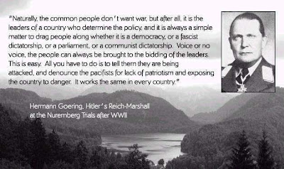


 Earth's magnetic field:

